When you take a flight to a nearby hub or sunny destination, you might notice that your aircraft always makes more turns than you’d think are necessary on the way. In fact, it’s almost unheard of for a commercial flight to fly in a straight line to its destination. So if the shortest distance between two points is a straight line (you’re welcome, math geeks), why are thousands of airplanes flying out of their way to get to their destinations? The answer lies in flight planning and air traffic flow.
Before a commercial flight takes off, the crew must file a flight plan. This plan shows the route the aircraft will take from the departure city to the arrival city — kind of like setting the GPS navigation for a road trip. Similarly, in the same way that cars use roads to reach their destinations, aircraft must spend the majority of a flight along pre-planned routes.
There is a system of organization that allows thousands of aircraft to share the skies safely; it includes airways, which aircraft follow in the sky, and specified points (kind of like invisible signs) that guide the aircraft, called fixed navigational aids (or navaids for short) and waypoints. Navaids are ground-based devices that have radio signals aircraft can pick up on. Waypoints are geographical points on the earth, with no physical device on the ground, that are loaded into the GPS systems of all commercial aircraft. All navaids are considered waypoints, and each waypoint has a 5-letter identifier that can be pronounced phonetically. One waypoint identifier that exists here at Asheville is “TUXDO,” pronounced “tuxedo.”
Every airway has its own name (just like Route 66 or I-40) and its own type (like interstates, highways or back roads). Airways below 18,000 feet (and that run directly between navaids) are called victor airways and those above 18,000 feet are called jet routes or jet airways. Newer airways that don’t run directly between navaids are called Q or T airways. Each airway is named by its corresponding letter (V for victor airways, J for jet airways and so on) and a number. For example, a flight plan that calls for the use of Jet Airway 6 will simply show J6.
In situations where there’s no suitable airway for a flight to follow, like extremely short flights or the switching of airways that don’t intersect, the flight plan will go from one waypoint to another directly.
One interesting fact about air traffic flow is that all westbound flights fly at even numbered altitudes (like 36,000 feet) and eastbound flights fly at odd numbered altitudes (15,000 feet, for example).
In addition to flying along airways and between waypoints, aircraft entering and departing a busy airspace (such as Atlanta or Chicago) have to fly very specific arrival and departure routes known as Standard Instrument Departures (SIDs) and Standard Terminal Arrival Routes (STARs). Like on-ramps and off-ramps on the highways of America, these routes exist to safely and efficiently flow lots of aircraft into and out of busy airports.
SID and STAR procedures are usually named after one of the waypoints within their routing and in many cases are creatively named with local relevance. Atlanta, for example, has a route named JCKTS 9, paying homage to the Georgia Tech Yellow Jackets and a route named “WARRR 1,” which overflies the campus of Auburn University, which has long used the saying “War Eagle.” You’ll notice that your flight into a hub city often takes a few minutes longer than the flight back to AVL because the STAR procedure into the hub typically requires a little extra flying to get all aircraft into one continuous line toward the runway.
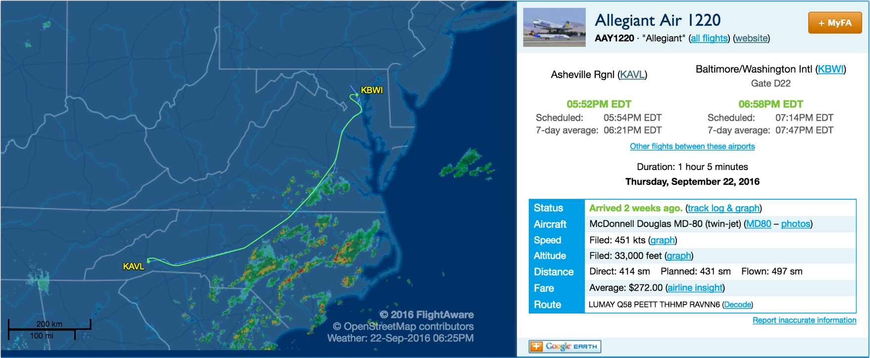
In this example of an Allegiant flight from AVL to Baltimore (BWI), you can see that the flight plan took the aircraft on a slightly curved route, which was about 80 miles longer than flying directly to BWI. Looking at the flight plan, next to “route,” you can see that the flight departed and made an immediate turn to the LUMAY waypoint, where it joined the Q58 airway and flew to the PEETT waypoint, where it then went directly to the THHMP waypoint to begin the RAVNN6 arrival into BWI. Whew! For the sports fans out there, we’d like to point out that the portion of this flight that began at THHMP was part of the Raven 6 arrival, which was named after the Baltimore Ravens football team.
As intricate as all this routing information may seem, most flights can upload a flight plan to the aircraft’s computers with the push of a button. Most airport pairs have a pre-set list of routing options depending upon the location of those two airports. There is typically a primary option and various backup routings for different weather situations en route.
Airports in less busy airspace do not have SID and STAR procedures unless issues, such as terrain (like mountains) require aircraft to fly in specific areas near the airport. When you fly from AVL you can bet that you’ll be flying a STAR when your flight approaches its destination and a SID when you leave that airport to return home.
Social Hub
Asheville Regional Airport to Open New North Concourse and New TSA Security Check Point June 25
Thank you @Fox Carolina News for spreading the word about our new North Concourse! #flyAVL #AVLForward https://www.foxcarolina.com/video/2025/06/25/new-concourse-asheville-regional-airport/
FRIENDLY REMINDER! Peak travel season is here. If flying, remember to arrive at least two hours prior to boarding. For helpful travel FAQs, visit https://t.co/GwLRHYn71b.
Art + Music
A NEW AVL IS ON THE HORIZON
Make your connection
AVL is connected to our community in many ways!
Learn MoreWe Saved You a Window Seat
Sign up for our monthly e-newsletter!